
Make a donation
Gear up for your next adventure:
As an Amazon Associate, this site earns from qualifying purchases at no extra cost to you.
Nünschweiler topographic map
Click on the map to display elevation.
Make a donation
Gear up for your next adventure:
As an Amazon Associate, this site earns from qualifying purchases at no extra cost to you.
Nünschweiler
Nünschweiler liegt im zum Zweibrücker Hügelland gehörenden Pirmasenser Hügelland zwischen den Ortschaften Rieschweiler-Mühlbach im Nordwesten, Dellfeld-Falkenbusch im Westen und Höheischweiler im Osten. Zu Nünschweiler gehören zusätzlich die Wohnplätze Bärenhütte, Bärenhütterhof, Dusenbrücken, Huberhof, Mittelscheiderhof und Morschelweiher. Im Süden des Gemeindegebiets fließt die Felsalb, die dort von links den Blümelsbach aufnimmt. Durch den Norden der Gemarkung verläuft der Aschbach.
Make a donation
Gear up for your next adventure:
As an Amazon Associate, this site earns from qualifying purchases at no extra cost to you.
About this map
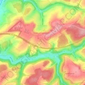
Name: Nünschweiler topographic map, elevation, terrain.
Average elevation: 1,037 ft
Minimum elevation: 764 ft
Maximum elevation: 1,227 ft
Make a donation
Gear up for your next adventure:
As an Amazon Associate, this site earns from qualifying purchases at no extra cost to you.