
Thank you for supporting this site ❤️
Make a donation
Make a donation
Gear up for your next adventure:
As an Amazon Associate, this site earns from qualifying purchases at no extra cost to you.
Hyoja-dong topographic map
Click on the map to display elevation.
Thank you for supporting this site ❤️
Make a donation
Make a donation
Gear up for your next adventure:
As an Amazon Associate, this site earns from qualifying purchases at no extra cost to you.
About this map
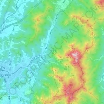
Name: Hyoja-dong topographic map, elevation, terrain.
Location: Hyoja-dong, Deogyang-gu, Goyang-si, Gyeonggi, South Korea (37.62937 126.90126 37.69302 126.99427)
Average elevation: 764 ft
Minimum elevation: 75 ft
Maximum elevation: 2,657 ft
Thank you for supporting this site ❤️
Make a donation
Make a donation
Gear up for your next adventure:
As an Amazon Associate, this site earns from qualifying purchases at no extra cost to you.