Geolocate

Maco topographic map

Click on the map to display elevation.

About this map

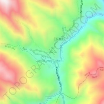
Name: Maco topographic map, elevation, terrain.

Location: Maco, Tapo, Province of Tarma, Junín, Peru (-11.50780 -75.57062 -11.46780 -75.53062)

Average elevation: 12,487 ft

Minimum elevation: 11,079 ft

Maximum elevation: 14,203 ft

Gear up for your next adventure:

🔦LED Headlamp - Bright and durable LED headlamp for night navigation
🪶Multi‑Purpose Knife - Useful blade for camp and trail
🔥Camping Stove - Portable stove for camping and backcountry cooking
🌧️Backpack Rain Cover - Keep gear dry in wet weather
🩳Quick‑Dry Hiking Shorts - Comfortable and quick‑dry shorts for summer hiking

As an Amazon Associate, this site earns from qualifying purchases at no extra cost to you.