
Chemba topographic map
Click on the map to display elevation.
About this map
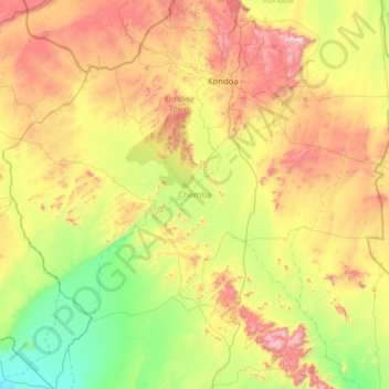
Name: Chemba topographic map, elevation, terrain.
Location: Chemba, Dodoma Region, Central Zone, Tanzania (-5.68535 35.06617 -4.85837 36.32452)
Average elevation: 4,131 ft
Minimum elevation: 2,713 ft
Maximum elevation: 7,067 ft
Other topographic maps
Click on a map to view its topography, its elevation and its terrain.
Dodoma
The official capital since 1996, Dodoma was envisaged as the first non-monumental capital city as opposed to the monumentality and hierarchy of other planned capital cities such as Abuja, Yamoussoukro, Brasília and Washington, D.C. It rejected geometrical forms such as grid iron and radial plans as…
Average elevation: 3,750 ft