Geolocate

Kembanglimus topographic map

Click on the map to display elevation.

About this map

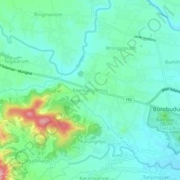
Name: Kembanglimus topographic map, elevation, terrain.

Location: Kembanglimus, Magelang, Central Java, Java, 56553, Indonesia (-7.61715 110.16343 -7.57715 110.20343)

Average elevation: 892 ft

Minimum elevation: 761 ft

Maximum elevation: 1,306 ft

Other topographic maps

Click on a map to view its topography, its elevation and its terrain.

Salam

Indonesia > Central Java > Magelang

Average elevation: 932 ft

Muntilan

Indonesia > Central Java > Magelang

Average elevation: 971 ft

Ngablak

Indonesia > Central Java > Magelang

Average elevation: 2,064 ft

Kaliurang

Indonesia > Central Java > Magelang

Average elevation: 2,520 ft

Gear up for your next adventure:

📶Vehicle Signal Boosters - Improve reception in rural areas while driving to trailheads
🎒Day Hiking Backpack - Lightweight backpack perfect for day trips and outdoor adventures
📌Outdoor GPS Map App - Apps and devices for digital topographic navigation
🧥Waterproof Jacket for Hiking - Breathable and rugged rain jacket for outdoor excursions
📚USA Hiking Guide Books - Top trail guides and map books

As an Amazon Associate, this site earns from qualifying purchases at no extra cost to you.