
Thank you for supporting this site ❤️
Make a donation
Make a donation
Gear up for your next adventure:
As an Amazon Associate, this site earns from qualifying purchases at no extra cost to you.
Mulgama topographic map
Click on the map to display elevation.
Thank you for supporting this site ❤️
Make a donation
Make a donation
Gear up for your next adventure:
As an Amazon Associate, this site earns from qualifying purchases at no extra cost to you.
About this map
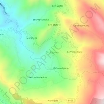
Name: Mulgama topographic map, elevation, terrain.
Location: Mulgama, Kandy District, Central Province, 20544, Sri Lanka (7.13458 80.65095 7.17458 80.69095)
Average elevation: 3,196 ft
Minimum elevation: 2,110 ft
Maximum elevation: 4,656 ft
Thank you for supporting this site ❤️
Make a donation
Make a donation
Gear up for your next adventure:
As an Amazon Associate, this site earns from qualifying purchases at no extra cost to you.