
Make a donation
Gear up for your next adventure:
As an Amazon Associate, this site earns from qualifying purchases at no extra cost to you.
Lac Rectangle topographic map
Click on the map to display elevation.
Make a donation
Gear up for your next adventure:
As an Amazon Associate, this site earns from qualifying purchases at no extra cost to you.
About this map
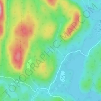
Name: Lac Rectangle topographic map, elevation, terrain.
Average elevation: 2,835 ft
Minimum elevation: 2,657 ft
Maximum elevation: 3,209 ft
Make a donation
Gear up for your next adventure:
As an Amazon Associate, this site earns from qualifying purchases at no extra cost to you.
Other topographic maps
Click on a map to view its topography, its elevation and its terrain.
Make a donation
Gear up for your next adventure:
As an Amazon Associate, this site earns from qualifying purchases at no extra cost to you.
Lac Saint-Jacques
Canada > Québec > La Côte-de-Beaupré > Lac-Jacques-Cartier
Average elevation: 2,982 ft
Lac Jacques-Cartier
Canada > Québec > La Côte-de-Beaupré > Lac-Jacques-Cartier
Average elevation: 2,851 ft
Lac aux Écorces
Canada > Québec > La Côte-de-Beaupré > Lac-Jacques-Cartier
Average elevation: 1,631 ft
Mont Raoul-Blanchard
Canada > Québec > La Côte-de-Beaupré > Lac-Jacques-Cartier
Average elevation: 3,222 ft
Make a donation
Gear up for your next adventure:
As an Amazon Associate, this site earns from qualifying purchases at no extra cost to you.
Rivière à l'Épaule
Canada > Québec > La Côte-de-Beaupré > Lac-Jacques-Cartier
Average elevation: 2,077 ft
Étang des Perce-Neige
Canada > Québec > La Côte-de-Beaupré > Lac-Jacques-Cartier
Average elevation: 1,621 ft