Geolocate

Heller topographic map

Click on the map to display elevation.

About this map

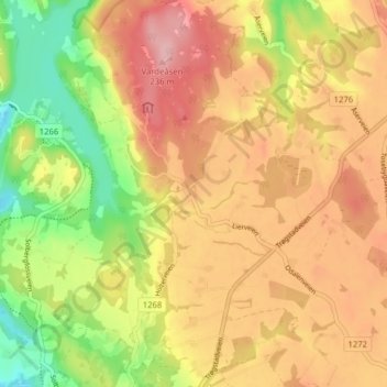
Name: Heller topographic map, elevation, terrain.

Location: Heller, Indre Østfold, Østfold, 1808, Norway (59.60854 11.17111 59.64854 11.21111)

Average elevation: 545 ft

Minimum elevation: 276 ft

Maximum elevation: 761 ft

Other topographic maps

Click on a map to view its topography, its elevation and its terrain.

Moss

Norway > Østfold

Average elevation: 75 ft

Fredrikstad

Norway > Østfold

Average elevation: 49 ft

Ullerøy leirskole

Norway > Østfold > Ullerøy

Average elevation: 46 ft

Skiptvet

Norway > Østfold

Average elevation: 381 ft

Moss

Norway > Østfold

Average elevation: 75 ft

Ertevannet

Norway > Østfold

Average elevation: 404 ft

Knivsøya

Norway > Østfold > Isebakke

Average elevation: 112 ft

Kinnekulle

Norway > Østfold

Average elevation: 486 ft

Halden

Norway > Østfold

Average elevation: 410 ft

Moss

Norway > Østfold

Average elevation: 75 ft

Fredrikstad

Norway > Østfold

Average elevation: 49 ft

Gear up for your next adventure:

⛑️Personal Locator Beacon - Safety beacon for emergencies
🥇GPS Hiking Watch - Multi‑sport GPS watch with navigation and trail tracking
🎁Geography Themed Gifts - Unique gift ideas for map lovers and geography enthusiasts
❄️Traction Cleats - Prevent slips on icy trails during winter hikes
Camping Coffee Makers - Enjoy premium coffee at the summit or campsite

As an Amazon Associate, this site earns from qualifying purchases at no extra cost to you.