
Yzerfontein topographic map
Click on the map to display elevation.
About this map
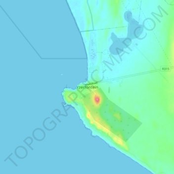
Name: Yzerfontein topographic map, elevation, terrain.
Average elevation: 26 ft
Minimum elevation: -7 ft
Maximum elevation: 276 ft
Other topographic maps
Click on a map to view its topography, its elevation and its terrain.
Dassen Island
South Africa > Western Cape > West Coast District Municipality > Swartland Local Municipality
Average elevation: 7 ft
Malmesbury
South Africa > Western Cape > West Coast District Municipality > Swartland Local Municipality
Average elevation: 561 ft
Darling Wildflower Nature Reserve
South Africa > Western Cape > West Coast District Municipality > Swartland Local Municipality > Darling
Average elevation: 486 ft