
Hinsdale topographic map
Interactive map
Click on the map to display elevation.
Hinsdale
Hinsdale is a village in Cook and DuPage counties in the U.S. state of Illinois. Hinsdale is a western suburb of Chicago. The population was 16,816 at the 2010 census, most of whom lived in DuPage County. The town's ZIP code is 60521. The town has a rolling, wooded topography, with a downtown, and is a 22-minute express train ride to downtown Chicago on the Burlington Northern line.
About this map
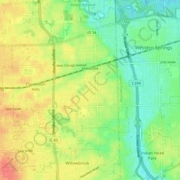
Name: Hinsdale topographic map, elevation, terrain.
Location: Hinsdale, DuPage County, Illinois, 60521, United States (41.76386 -87.95244 41.82575 -87.90002)
Average elevation: 705 ft
Minimum elevation: 627 ft
Maximum elevation: 801 ft
DuPage County trails, hiking, mountain biking, running and outdoor activities
Other topographic maps
Click on a map to view its topography, its elevation and its terrain.
Downers Grove
United States > Illinois > DuPage County > Downers Grove > Downers Grove
Average elevation: 745 ft