
Thank you for supporting this site ❤️
Make a donation
Make a donation
Gear up for your next adventure:
As an Amazon Associate, this site earns from qualifying purchases at no extra cost to you.
Reither Anger topographic map
Click on the map to display elevation.
Thank you for supporting this site ❤️
Make a donation
Make a donation
Gear up for your next adventure:
As an Amazon Associate, this site earns from qualifying purchases at no extra cost to you.
About this map
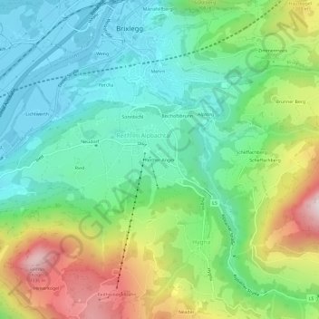
Name: Reither Anger topographic map, elevation, terrain.
Average elevation: 2,562 ft
Minimum elevation: 1,686 ft
Maximum elevation: 4,393 ft
Thank you for supporting this site ❤️
Make a donation
Make a donation
Gear up for your next adventure:
As an Amazon Associate, this site earns from qualifying purchases at no extra cost to you.
Other topographic maps
Click on a map to view its topography, its elevation and its terrain.
Alpbachtal
Österreich > Tirol > Bezirk Kufstein > Hygna
Höhere und touristisch gut erschlossene Gipfel im Alpbachtal sind
Average elevation: 4,078 ft