Geolocate
👉 Easily get elevation data in JSON, GeoTIFF and KML formats using Elevation API
Thank you for supporting this site ❤️
Make a donation

Vucht topographic map

Click on the map to display elevation.

Vucht

Vucht ligt tussen de Maas en de Zuid-Willemsvaart, in het dal van de Maas, op een hoogte van ongeveer 43 meter. Ten zuiden van Vucht bevindt zich het natuurgebied Maaswinkel.

Wikipedia (CC-BY-SA 3.0)

About this map

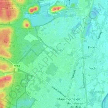
Name: Vucht topographic map, elevation, terrain.

Location: Vucht, Maasmechelen, Tongeren, Limburg, Vlaanderen, België (50.96877 5.66020 50.99782 5.73544)

Average elevation: 128 ft

Minimum elevation: 92 ft

Maximum elevation: 308 ft

Other topographic maps

Click on a map to view its topography, its elevation and its terrain.

Proosterbos

België > Limburg > Tongeren > Maasmechelen

Average elevation: 154 ft

Mechelse Heide

België > Limburg > Tongeren > Maasmechelen

Average elevation: 210 ft

Rode Terril

België > Limburg > Tongeren > Maasmechelen

Average elevation: 187 ft

Daalgrimbie

België > Limburg > Tongeren > Maasmechelen > Opgrimbie > Daalgrimbie

Average elevation: 144 ft

Gear up for your next adventure:

🔦LED Headlamp - Bright and durable LED headlamp for night navigation
🥾Hiking Shoes - Durable and comfortable shoes for trail hiking
🏔️Mountain Trail Maps - High‑detail maps for popular peaks
🗺️Topographic Maps - Detailed topo maps for hiking, exploring and outdoor navigation
👟Trail Running Shoes - Lightweight shoes for trail runners

As an Amazon Associate, this site earns from qualifying purchases at no extra cost to you.