Geolocate

Strathbogie topographic map

Click on the map to display elevation.

About this map

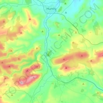
Name: Strathbogie topographic map, elevation, terrain.

Location: Strathbogie, Huntly, Aberdeenshire, Scotland, United Kingdom (57.32524 -2.83316 57.45845 -2.76949)

Average elevation: 784 ft

Minimum elevation: 338 ft

Maximum elevation: 1,847 ft

Other topographic maps

Click on a map to view its topography, its elevation and its terrain.

Affleck

United Kingdom > Scotland > Aberdeenshire > Huntly

Average elevation: 443 ft

Gear up for your next adventure:

🧢Outdoor Hiking Hat - Sun protection hat for outdoor explorers
🌐World Map Poster - Decorative world maps with topographic info
🗻Climbing Gear Basics - Essential gear for beginner climbers
🧷Carabiner Set - Durable clips for gear attachment
🔋Rechargeable Batteries - Power up your outdoor devices

As an Amazon Associate, this site earns from qualifying purchases at no extra cost to you.