
Cowee topographic map
Click on the map to display elevation.
About this map
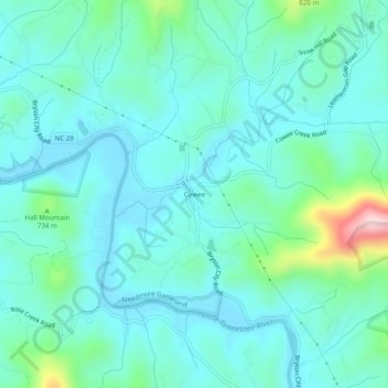
Name: Cowee topographic map, elevation, terrain.
Location: Cowee, Macon County, North Carolina, United States (35.24121 -83.42793 35.28121 -83.38793)
Average elevation: 2,119 ft
Minimum elevation: 1,926 ft
Maximum elevation: 3,028 ft
Macon County trails, hiking, mountain biking, running and outdoor activities
Other topographic maps
Click on a map to view its topography, its elevation and its terrain.
Little Tennessee River
United States > North Carolina > Macon County > Franklin > East Franklin
Average elevation: 2,103 ft