
Make a donation
Gear up for your next adventure:
As an Amazon Associate, this site earns from qualifying purchases at no extra cost to you.
Calau topographic map
Click on the map to display elevation.
Make a donation
Gear up for your next adventure:
As an Amazon Associate, this site earns from qualifying purchases at no extra cost to you.
Calau
In Calau steht die Napoleoneiche mit einem Brusthöhenumfang von 7,30 m (2016).
Make a donation
Gear up for your next adventure:
As an Amazon Associate, this site earns from qualifying purchases at no extra cost to you.
About this map
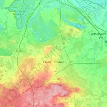
Name: Calau topographic map, elevation, terrain.
Location: Calau, Oberspreewald-Lausitz, Brandenburg, 03205, Deutschland (51.67841 13.79822 51.83892 14.05045)
Average elevation: 272 ft
Minimum elevation: 141 ft
Maximum elevation: 522 ft
Make a donation
Gear up for your next adventure:
As an Amazon Associate, this site earns from qualifying purchases at no extra cost to you.
Other topographic maps
Click on a map to view its topography, its elevation and its terrain.
Missen
Deutschland > Brandenburg > Oberspreewald-Lausitz > Vetschau/Spreewald
Average elevation: 236 ft
Belten
Deutschland > Brandenburg > Oberspreewald-Lausitz > Vetschau/Spreewald
Average elevation: 210 ft
Make a donation
Gear up for your next adventure:
As an Amazon Associate, this site earns from qualifying purchases at no extra cost to you.
Muckwar
Deutschland > Brandenburg > Oberspreewald-Lausitz > Luckaitztal
Mitte des 19. Jahrhunderts hatte das Rittergut Muckwar eine Fläche von 2232 Morgen und eine Schatzung von 800 Gulden an die Lehnsherren abzugeben. Zusammen mit dem Rittergut Wüstenhain hatte Muckwar im Bedarfsfall ein Pferd zu stellen. Die Bewohner lebten von der Landwirtschaft und der Karpfenzucht. Laut der…
Average elevation: 285 ft
Make a donation
Gear up for your next adventure:
As an Amazon Associate, this site earns from qualifying purchases at no extra cost to you.
Großer Großmanns Berg
Deutschland > Brandenburg > Oberspreewald-Lausitz > Calau
Average elevation: 397 ft