
Make a donation
Gear up for your next adventure:
As an Amazon Associate, this site earns from qualifying purchases at no extra cost to you.
Rheinweiler topographic map
Click on the map to display elevation.
Make a donation
Gear up for your next adventure:
As an Amazon Associate, this site earns from qualifying purchases at no extra cost to you.
About this map
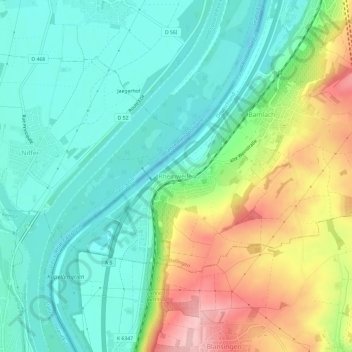
Name: Rheinweiler topographic map, elevation, terrain.
Average elevation: 886 ft
Minimum elevation: 689 ft
Maximum elevation: 1,293 ft
Make a donation
Gear up for your next adventure:
As an Amazon Associate, this site earns from qualifying purchases at no extra cost to you.
Other topographic maps
Click on a map to view its topography, its elevation and its terrain.
Schönau im Schwarzwald
Deutschland > Baden-Württemberg > Landkreis Lörrach
Der staatlich anerkannte Luftkurort Schönau im Schwarzwald liegt im oberen Wiesental am Oberlauf der Großen Wiese, umgeben von den Erhebungen des südlichen Schwarzwaldes, in 517 bis 1309 Meter Höhe.
Average elevation: 2,779 ft
Lörrach
Deutschland > Baden-Württemberg > Landkreis Lörrach
Lörrach ist eine Kreisstadt im Südwesten Baden-Württembergs. Sie ist die größte Stadt des gleichnamigen Landkreises und seit dem 1. April 1956 Große Kreisstadt. In der näheren Umgebung liegen der Schwarzwald, das Rheintal sowie Weil am Rhein und die Schweizer Großstadt Basel. Bedeutendste…
Average elevation: 1,168 ft
Efringen-Kirchen
Deutschland > Baden-Württemberg > Landkreis Lörrach
Efringen-Kirchen liegt in der Oberrheinebene in 240 bis 396 Meter Höhe und grenzt direkt an den Rhein, der hier die Grenze zu Frankreich bildet. Es ist Teil des Markgräfler Landes.
Average elevation: 951 ft
Rheinfelden (Baden)
Deutschland > Baden-Württemberg > Landkreis Lörrach
1894 erteilten das Großherzogtum Baden und der Kanton Aargau dem Unternehmen Kraftübertragungswerke Rheinfelden (KWR) die Konzession für den Bau von Europas erstem bedeutenden Laufwasserkraftwerk. Um dessen Rentabilität zu erhöhen, schuf die KWR die Voraussetzungen zur Ansiedlung energieintensiver…
Average elevation: 1,191 ft
Make a donation
Gear up for your next adventure:
As an Amazon Associate, this site earns from qualifying purchases at no extra cost to you.
Weil am Rhein
Deutschland > Baden-Württemberg > Landkreis Lörrach
Weil am Rhein liegt in der Rheinebene am Rande des Tüllinger Bergs im Osten und reicht im Westen bis an den Rhein. Die besondere Lage zwischen dem Rhein und den Ausläufern des Schwarzwaldes begünstigt u. a. auch durch die Nähe zur Burgundischen Pforte ein außergewöhnlich südländisches Klima und bietet…
Average elevation: 935 ft
79669
Deutschland > Baden-Württemberg > Landkreis Lörrach > Zell im Wiesental > Adelsberg
Average elevation: 2,290 ft
Kandern
Deutschland > Baden-Württemberg > Landkreis Lörrach
Südlich der Schwarzwaldsüdrandverwerfung bezieht das Gemeindegebiet neben dem höchsten Teil des Munzenbergs (702 m) auch den Gugelhut und den Günglert mit ein. Auch hier, im Weitenauer Bergland, sind wir im Bereich der Schwarzwaldvorberge. Es stehen aber hier viel ältere Schichten an – Buntsandstein und…
Average elevation: 1,476 ft
Schopfheim
Deutschland > Baden-Württemberg > Landkreis Lörrach
Im rissig-klüftigen Oberen Muschelkalk versinken die Niederschläge, sodass auf der Höhe des östlichen Dinkelbergs keine dauerhaften Fließgewässer vorhanden sind. Hier beherrschen auf Schopfheims Gemarkung Trockentäler und Dolinen das Landschaftsbild. Es handelt sich also um eine ausgeprägte…
Average elevation: 1,781 ft
Make a donation
Gear up for your next adventure:
As an Amazon Associate, this site earns from qualifying purchases at no extra cost to you.
Todtnau
Deutschland > Baden-Württemberg > Landkreis Lörrach
Todtnau liegt im Südschwarzwald zwischen Feldberg und Belchen in 570 bis 1390 Metern Höhe im Wiesental. Mehr als 60 % des Gemeindegebiets sind von Wald bedeckt.
Average elevation: 3,238 ft
Zell im Wiesental
Deutschland > Baden-Württemberg > Landkreis Lörrach
Zell im Wiesental bildet das Zentrum des Zeller Berglandes, das sich im südlichsten Teil des Schwarzwaldes auf einer Höhe von 415 bis 1300 m über NN zwischen Basel und dem Feldberg im großen Wiesental erstreckt. Dominierende Berge sind zum einen der Zeller Blauen (1077 m) nördlich von Zell und die auf…
Average elevation: 2,267 ft
Kleines Wiesental
Deutschland > Baden-Württemberg > Landkreis Lörrach
Die Gemeinde liegt auf einer Höhe von 300 bis 1400 Metern.
Average elevation: 2,359 ft
Make a donation
Gear up for your next adventure:
As an Amazon Associate, this site earns from qualifying purchases at no extra cost to you.
Malsburg-Marzell
Deutschland > Baden-Württemberg > Landkreis Lörrach
Die Doppelgemeinde Malsburg-Marzell liegt im Oberen Kandertal im südwestlichen Schwarzwald. Das Gemeindegebiet erstreckt sich über eine Höhenlage von 429 Meter über NN bis zum 1165 Meter hohen Blauen (auch Hochblauen) und ist zu mehr als 70 % von Wald bedeckt. Im Nordosten ist die Gemeinde über den…
Average elevation: 2,375 ft
Utzenfeld
Deutschland > Baden-Württemberg > Landkreis Lörrach
Das Gemeindegebiet Utzenfelds liegt in 560 bis 1124 Meter Höhe im oberen Wiesental im Naturpark Südschwarzwald. Der Kernort erstreckt sich entlang des rechten Ufers der Wiese zwischen den Städten Schönau im Schwarzwald und Todtnau.
Average elevation: 2,552 ft
Maulburg
Deutschland > Baden-Württemberg > Landkreis Lörrach
Nahe der östlichen Gemarkungsgrenze quert eine NW-SO ziehende Verwerfung, die sog. Maulburg-Schwörstadt-Verwerfung das Wintertal („Wintleter“). Diese setzt bei der Hasenweid Muschelkalk (offenes Gelände) gegen Rotliegendes und Buntsandstein (Wald). Sie zieht weiter Richtung Schwörstadt und bildet so…
Average elevation: 1,424 ft
Make a donation
Gear up for your next adventure:
As an Amazon Associate, this site earns from qualifying purchases at no extra cost to you.
Ehrsberg
Deutschland > Baden-Württemberg > Landkreis Lörrach
Häg-Ehrsberg liegt auf 540 bis 1192 m ü. NN Höhe im Angenbachtal, einem Seitental des Wiesentals im Naturpark Südschwarzwald. Der Angenbach entsteht beim Ortsteil Happach durch den Zusammenfluss kleinerer Quellbäche, zieht sich dann in südwestlicher Richtung durch die gesamte Gemarkung und mündet im…
Average elevation: 2,523 ft
Riedlingen
Deutschland > Baden-Württemberg > Landkreis Lörrach > Kandern
Alle geologischen Einheiten der Gemarkung gehören zur Vorbergzone des Schwarzwaldes und bestehen aus Bruchschollen des Deckgebirges, das einst auch die Höhen des Schwarzwaldes bedeckte, dort aber längst der Abtragung zum Opfer gefallen ist. Bei der Rheingrabenbildung bzw. dem verstärkten Aufsteigen des…
Average elevation: 1,217 ft
Make a donation
Gear up for your next adventure:
As an Amazon Associate, this site earns from qualifying purchases at no extra cost to you.
Rümmingen
Deutschland > Baden-Württemberg > Landkreis Lörrach
Zum Rümminger Gemarkungsgebiet gehört die Passhöhe des Wittlinger Bucks (437 m), der allerdings nur von Haagen und Wittlingen befahrbar ist.
Average elevation: 1,099 ft
Hasel
Deutschland > Baden-Württemberg > Landkreis Lörrach
In der Schopfheimer Bucht haben sich Schichten des Deckgebirges erhalten, die beim Aufsteigen des Schwarzwaldes auf dessen Höhen weitgehend abgetragen wurden. In der Nordostecke dieser Bucht, im Bruchschollenfeld von Hasel, sind diese Schichten, Oberrotliegendes, Zechstein (Wiesentalformation), Buntsandstein,…
Average elevation: 1,936 ft
Make a donation
Gear up for your next adventure:
As an Amazon Associate, this site earns from qualifying purchases at no extra cost to you.
Todtnauberg
Deutschland > Baden-Württemberg > Landkreis Lörrach > Todtnau
Der Todtnauberger Wasserfall ist mit 97 Metern Fallhöhe in fünf Fallstufen einer der höchsten Wasserfälle Deutschlands.
Average elevation: 3,665 ft
Tunau
Deutschland > Baden-Württemberg > Landkreis Lörrach
Tunau liegt am Rand des Wiesentals im Naturpark Südschwarzwald in 580 bis 1163 Meter Höhe.
Average elevation: 2,733 ft
Make a donation
Gear up for your next adventure:
As an Amazon Associate, this site earns from qualifying purchases at no extra cost to you.
Wittlingen
Deutschland > Baden-Württemberg > Landkreis Lörrach
Eine kleine Besonderheit ist, dass der Kulminationspunkt der Wittlinger Höhe (437 m ü. NHN) entgegen der namentlichen Bezeichnung nicht zum Gemeindegebiet von Wittlingen, sondern Rümmingen gehört.
Average elevation: 1,161 ft
Weil-Ost
Deutschland > Baden-Württemberg > Landkreis Lörrach > Weil am Rhein
Average elevation: 971 ft
Make a donation
Gear up for your next adventure:
As an Amazon Associate, this site earns from qualifying purchases at no extra cost to you.
Fröhnd
Deutschland > Baden-Württemberg > Landkreis Lörrach
Fröhnd liegt im Wiesental in 500 bis 1200 Meter Höhe im Naturpark Südschwarzwald, wo auch der Schwammbrunnenbach verläuft.
Average elevation: 2,513 ft
Tumringen
Deutschland > Baden-Württemberg > Landkreis Lörrach > Lörrach (Kernstadt)
Average elevation: 1,115 ft
Lörrach (Kernstadt)
Deutschland > Baden-Württemberg > Landkreis Lörrach > Untertüllingen
Lörrach ist eine Kreisstadt im Südwesten Baden-Württembergs. Sie ist die größte Stadt des gleichnamigen Landkreises und seit dem 1. April 1956 Große Kreisstadt. In der näheren Umgebung liegen der Schwarzwald, das Rheintal und die Schweizer Großstadt Basel. Mit der westlich gelegenen Nachbarstadt Weil…
Average elevation: 1,145 ft
Schwörstadt
Deutschland > Baden-Württemberg > Landkreis Lörrach
Schwörstadt liegt in einer Höhe von 296 bis 481 Metern unmittelbar zwischen dem Hochrhein im Süden und dem Dinkelberg, einem südlich vom Südschwarzwald gelagerten kleinen Gebirgszug, im Norden. Der Ortsteil Dossenbach liegt etwa drei Kilometer nördlich von Schwörstadt auf dem Dinkelberg. Der Ortsteil…
Average elevation: 1,289 ft
Make a donation
Gear up for your next adventure:
As an Amazon Associate, this site earns from qualifying purchases at no extra cost to you.
Ötlingen
Deutschland > Baden-Württemberg > Landkreis Lörrach > Weil am Rhein
Der Steilabfall am Westende des Ötlinger Berges ist der Erosionsleistung des Rheins zu verdanken, der noch in der vorletzten Kaltzeit (Risskaltzeit) den unteren Bühlhang umspülte und hier Schotter in bis 300 m Höhe hinterließ (Hochterrassenschotter).
Average elevation: 1,063 ft
Schliengen
Deutschland > Baden-Württemberg > Landkreis Lörrach
Schliengen liegt zwischen Müllheim und der Kreisstadt Lörrach. Das Gemeindegebiet erstreckt sich von der Oberrheinebene in 225 Meter über Normalnull, über die Vorbergzone des Eggenertals bis zum Gipfel des Blauen (auch Hochblauen) in 1165 Meter Höhe.
Average elevation: 971 ft
Gresgen
Deutschland > Baden-Württemberg > Landkreis Lörrach > Zell im Wiesental
Klimatisch macht sich die Höhendifferenz von rund 300 Metern gegenüber Zell bemerkbar. So beginnt die Apfelblüte in den Bergorten wie Gresgen in der Regel erst Mitte Mai und damit rund eineinhalb Wochen später als im Tal. Auch ist die Niederschlagsmenge gegenüber der Zeller Kernstadt höher, die…
Average elevation: 2,156 ft
Wieden
Deutschland > Baden-Württemberg > Landkreis Lörrach
Der staatlich anerkannte Erholungsort Wieden liegt in einem Hochtal nordöstlich des Belchen (1414,2 m) im Naturpark Südschwarzwald in 740 bis 1280 Meter Höhe.
Average elevation: 3,389 ft
Make a donation
Gear up for your next adventure:
As an Amazon Associate, this site earns from qualifying purchases at no extra cost to you.
Holzen
Deutschland > Baden-Württemberg > Landkreis Lörrach > Kandern
Holzen liegt westlich des Kandertals und westlich des Wollbacher Nebenorts Hammerstein sowie östlich von Tannenkirch auf einer leichten Anhöhe inmitten der Markgräfler Hügellandschaft am Rande der breiten Feuerbachmulde. Holzen liegt knapp fünf Kilometer südöstlich von Kandern entfernt.
Average elevation: 1,102 ft
Inzlingen
Deutschland > Baden-Württemberg > Landkreis Lörrach
Westlich einer großen von Lörrach nach Degerfelden ziehenden Verwerfung ist die Muschelkalktafel des Dinkelbergs stärker herausgehoben. Außerdem lässt sich eine leichte Aufwölbung der Gesteinsschichten um Inzlingen nachweisen. Die Achse dieses Sattels (einer Antiklinale) verläuft etwa West-Ost-Richtung…
Average elevation: 1,388 ft
Rosenfelspark
Deutschland > Baden-Württemberg > Landkreis Lörrach > Lörrach (Kernstadt)
Average elevation: 1,096 ft
Haltingen
Deutschland > Baden-Württemberg > Landkreis Lörrach > Weil am Rhein
Haltingen | Märkt | Ötlingen | Kernstadt (Leopoldshöhe) mit den Ortsteilen Alt-Weil, Friedlingen und Otterbach
Average elevation: 991 ft
Make a donation
Gear up for your next adventure:
As an Amazon Associate, this site earns from qualifying purchases at no extra cost to you.
Aitern
Deutschland > Baden-Württemberg > Landkreis Lörrach
Aitern liegt in 580 bis 1.274 Meter Höhe im Tal des Aiternbachs, das sich vom Osthang des 1414 m ü. NHN hohen Belchen in das Wiesental hinabzieht. Das Gemeindegebiet deckt sich weitestgehend mit dem Einzugsgebiet des Aiternbachs. Aus diesem Grund verlaufen die Gemeindegrenzen entlang der Wasserscheiden.…
Average elevation: 2,867 ft
Steinen
Deutschland > Baden-Württemberg > Landkreis Lörrach
Die Gesamtgemeinde Steinen liegt im Vorderen Wiesental des Südschwarzwalds. Mit dem Steinenbachtal als Nord-Süd-Achse bildet die Gemeinde Steinen einen geographischen Querriegel zum Wiesental. Insgesamt erstreckt sich die Gemeinde in der größten Nord-Süd-Ausdehnung über 14 km, die Höhendifferenz…
Average elevation: 1,598 ft
Isteiner Klotz
Deutschland > Baden-Württemberg > Landkreis Lörrach > Istein
Das Klima ist gekennzeichnet durch hohe Temperaturen und geringe Niederschläge. Die Früh- und Spätfröste sind seltener als in der Ebene, der Isteiner Klotz ragt meistens aus den herbst- und winterlichen Nebellagen heraus bei deutlich höheren Durchschnittstemperaturen. Zusammengefasst ist das Gebiet…
Average elevation: 912 ft
Nonnenmattweiher
Deutschland > Baden-Württemberg > Landkreis Lörrach > Neuenweg > Hinterheubronn
Der Nonnenmattweiher ist ursprünglich als Karsee durch einen Gletscher (Wiesentalgletscher) in der Eiszeit entstanden, war aber wohl schon im Mittelalter verlandet und von einem Hochmoor und anmoorigen Weiden eingenommen. Der Aufstau im Jahre 1758 erfolgte durch den Lörracher Landvogt von Wallbrunn und…
Average elevation: 3,140 ft
Make a donation
Gear up for your next adventure:
As an Amazon Associate, this site earns from qualifying purchases at no extra cost to you.
Biosphärengebiet Schwarzwald
Deutschland > Baden-Württemberg > Landkreis Lörrach
Average elevation: 2,480 ft
Nonnenmattweiher
Deutschland > Baden-Württemberg > Landkreis Lörrach > Kleines Wiesental > Hinterheubronn
Average elevation: 3,133 ft
79618
Deutschland > Baden-Württemberg > Landkreis Lörrach > Rheinfelden (Baden) > Niedereichsel
Average elevation: 1,227 ft
Fischingen
Deutschland > Baden-Württemberg > Landkreis Lörrach
Fischingen liegt im südlichen Markgräflerland am Westhang des Läufelbergs (393 m) im äußersten Südwesten Deutschlands nahe der Schweizer und der französischen Grenze. Das Besiedlungsgebiet erstreckt sich von 279 m bis 290 m und liegt damit rund 20 Meter höher als der Rhein, der rund 2,5 Kilometer…
Average elevation: 984 ft
Make a donation
Gear up for your next adventure:
As an Amazon Associate, this site earns from qualifying purchases at no extra cost to you.
Fischingen
Deutschland > Baden-Württemberg > Landkreis Lörrach
Fischingen liegt im südlichen Markgräflerland am Westhang des Läufelbergs (393 m) im äußersten Südwesten Deutschlands nahe der Schweizer und der französischen Grenze. Das Besiedlungsgebiet erstreckt sich von 279 m bis 290 m und liegt damit rund 20 Meter höher als der Rhein, der rund 2,5 Kilometer…
Average elevation: 984 ft
Efringen-Kirchen
Deutschland > Baden-Württemberg > Landkreis Lörrach
Efringen-Kirchen liegt in der Oberrheinebene in 240 bis 396 Meter Höhe und grenzt direkt an den Rhein, der hier die Grenze zu Frankreich bildet. Es ist Teil des Markgräfler Landes.
Average elevation: 951 ft
Weil am Rhein
Deutschland > Baden-Württemberg > Landkreis Lörrach
Weil am Rhein liegt in der Rheinebene am Rande des Tüllinger Bergs im Osten und reicht im Westen bis an den Rhein. Die besondere Lage zwischen dem Rhein und den Ausläufern des Schwarzwaldes begünstigt u. a. auch durch die Nähe zur Burgundischen Pforte ein außergewöhnlich südländisches Klima und bietet…
Average elevation: 935 ft
Schliengen
Deutschland > Baden-Württemberg > Landkreis Lörrach
Schliengen liegt zwischen Müllheim und der Kreisstadt Lörrach. Das Gemeindegebiet erstreckt sich von der Oberrheinebene in 225 Meter über Normalnull, über die Vorbergzone des Eggenertals bis zum Gipfel des Blauen (auch Hochblauen) in 1165 Meter Höhe.
Average elevation: 971 ft
Make a donation
Gear up for your next adventure:
As an Amazon Associate, this site earns from qualifying purchases at no extra cost to you.
Rheinfelden (Baden)
Deutschland > Baden-Württemberg > Landkreis Lörrach
1894 erteilten das Großherzogtum Baden und der Kanton Aargau dem Unternehmen Kraftübertragungswerke Rheinfelden (KWR) die Konzession für den Bau von Europas erstem bedeutenden Laufwasserkraftwerk. Um dessen Rentabilität zu erhöhen, schuf die KWR die Voraussetzungen zur Ansiedlung energieintensiver…
Average elevation: 1,191 ft
Lörrach (Kernstadt)
Deutschland > Baden-Württemberg > Landkreis Lörrach > Untertüllingen
Lörrach ist eine Kreisstadt im Südwesten Baden-Württembergs. Sie ist die größte Stadt des gleichnamigen Landkreises und seit dem 1. April 1956 Große Kreisstadt. In der näheren Umgebung liegen der Schwarzwald, das Rheintal und die Schweizer Großstadt Basel. Mit der westlich gelegenen Nachbarstadt Weil…
Average elevation: 1,145 ft
Make a donation
Gear up for your next adventure:
As an Amazon Associate, this site earns from qualifying purchases at no extra cost to you.
79650
Deutschland > Baden-Württemberg > Landkreis Lörrach > Schopfheim > Scheuermatt
Average elevation: 2,014 ft
Kandern
Deutschland > Baden-Württemberg > Landkreis Lörrach
Südlich der Schwarzwaldsüdrandverwerfung bezieht das Gemeindegebiet neben dem höchsten Teil des Munzenbergs (702 m) auch den Gugelhut und den Günglert mit ein. Auch hier, im Weitenauer Bergland sind wir im Bereich der Schwarzwaldvorberge. Es stehen aber hier viel ältere Schichten an – Buntsandstein und…
Average elevation: 1,476 ft
Hasel
Deutschland > Baden-Württemberg > Landkreis Lörrach
In der Schopfheimer Bucht haben sich Schichten des Deckgebirges erhalten, die beim Aufsteigen des Schwarzwaldes auf dessen Höhen weitgehend abgetragen wurden. In der Nordostecke dieser Bucht, im Bruchschollenfeld von Hasel, sind diese Schichten, Oberrotliegendes, Zechstein (Wiesentalformation), Buntsandstein,…
Average elevation: 1,936 ft
Lörrach
Deutschland > Baden-Württemberg > Landkreis Lörrach
Lörrach ist eine Kreisstadt im Südwesten Baden-Württembergs. Sie ist die größte Stadt des gleichnamigen Landkreises und seit dem 1. April 1956 Große Kreisstadt. In der näheren Umgebung liegen der Schwarzwald, das Rheintal und die Schweizer Großstadt Basel. Mit der westlich gelegenen Nachbarstadt Weil…
Average elevation: 1,168 ft
Make a donation
Gear up for your next adventure:
As an Amazon Associate, this site earns from qualifying purchases at no extra cost to you.
Zell im Wiesental
Deutschland > Baden-Württemberg > Landkreis Lörrach
Zell im Wiesental bildet das Zentrum des Zeller Berglandes, das sich im südlichsten Teil des Schwarzwaldes auf einer Höhe von 415 bis 1300 m über NN zwischen Basel und dem Feldberg im großen Wiesental erstreckt. Dominierende Berge sind zum einen der Zeller Blauen (1077 m) nördlich von Zell und die auf…
Average elevation: 2,267 ft
Fischingen
Deutschland > Baden-Württemberg > Landkreis Lörrach
Fischingen liegt im südlichen Markgräflerland am Westhang des Läufelbergs (393 m) im äußersten Südwesten Deutschlands nahe der Schweizer und der französischen Grenze. Das Besiedlungsgebiet erstreckt sich von 279 m bis 290 m und liegt damit rund 20 Meter höher als der Rhein, der rund 2,5 Kilometer…
Average elevation: 984 ft