Geolocate

Ambridge topographic map

Click on the map to display elevation.

About this map

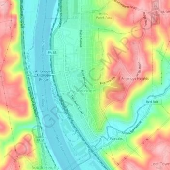
Name: Ambridge topographic map, elevation, terrain.

Location: Ambridge, Beaver County, Pennsylvania, United States (40.57308 -80.23660 40.60760 -80.20873)

Average elevation: 889 ft

Minimum elevation: 676 ft

Maximum elevation: 1,181 ft

Beaver County trails, hiking, mountain biking, running and outdoor activities

Other topographic maps

Click on a map to view its topography, its elevation and its terrain.

Gear up for your next adventure:

🧦Merino Wool Socks - Moisture-wicking, blister-preventing socks for long treks
🪶Paracord Bracelet - Survival bracelet with built‑in tools
🪶Camping Sleeping Pad - Comfortable sleeping pad for backpacking
🪑Ultralight Camp Chairs - Portable seating for resting after a long day of mapping
⛑️Personal Locator Beacon - Safety beacon for emergencies

As an Amazon Associate, this site earns from qualifying purchases at no extra cost to you.