
Perinthalmanna topographic map
Click on the map to display elevation.
About this map
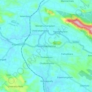
Name: Perinthalmanna topographic map, elevation, terrain.
Location: Perinthalmanna, Malappuram, Kerala, 679322, India (10.93568 76.18626 11.01568 76.26626)
Average elevation: 249 ft
Minimum elevation: 75 ft
Maximum elevation: 1,355 ft
Other topographic maps
Click on a map to view its topography, its elevation and its terrain.
Kolaparamba
India > Kerala > Perinthalmanna > Kollithodi SC Colony > Pattiyiparamb SC colony
Average elevation: 203 ft
Temple Pond, Bhagavathi Padam, Angadippuram
India > Kerala > Perinthalmanna > Angadipuram
Average elevation: 148 ft