
Thank you for supporting this site ❤️
Make a donation
Make a donation
Gear up for your next adventure:
As an Amazon Associate, this site earns from qualifying purchases at no extra cost to you.
Escalos de Cima e Lousa topographic map
Click on the map to display elevation.
Thank you for supporting this site ❤️
Make a donation
Make a donation
Gear up for your next adventure:
As an Amazon Associate, this site earns from qualifying purchases at no extra cost to you.
About this map
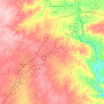
Name: Escalos de Cima e Lousa topographic map, elevation, terrain.
Location: Escalos de Cima e Lousa, Castelo Branco, Portugal (39.89819 -7.42384 39.98281 -7.32133)
Average elevation: 1,086 ft
Minimum elevation: 581 ft
Maximum elevation: 1,368 ft
Thank you for supporting this site ❤️
Make a donation
Make a donation
Gear up for your next adventure:
As an Amazon Associate, this site earns from qualifying purchases at no extra cost to you.
Other topographic maps
Click on a map to view its topography, its elevation and its terrain.