
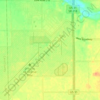
Grissom Air Reserve Base topographic map
Interactive map
Click on the map to display elevation.
About this map
Name: Grissom Air Reserve Base topographic map, elevation, terrain.
Average elevation: 801 ft
Minimum elevation: 738 ft
Maximum elevation: 846 ft
Upon receiving the Letter of Intent on 28 March 1942, Russell B. Moore Company established a temporary headquarters and moved personnel and necessary drafting, surveying and office equipment and supplies to an old schoolhouse at Bunker Hill, which they occupied until completion of the Construction Engineering Office on the site 13 May 1942. Surveying the site started 1 April 1942. J.L. Simmons Company, Inc. and United Construction Company received their Letter of Intent 4 April 1942, and immediately began moving equipment in to clear the site, including removal of buildings, trees, and grading as soon as elevations for the finished grade had been determined. Temporary structures were built, including a cement warehouse, a large general warehouse, 200 ft × 75 ft (61 m × 23 m), time office, a large number of movable, built on skids for easy removal, tool storage sheds and small storehouses. All construction material was delivered by truck until the completion of the spur track on 10 June 1942, after which a large portion of the construction material came in by rail. Peak days of traffic volume were as follows: 129 freight carloads of paving material received via the spur track on 30 October 1942, and 1755 truck loads of paving material received on 25 October 1942.
Other topographic maps
Click on a map to view its topography, its elevation and its terrain.
Miami
United States > Indiana > Miami County
Miami, Miami County, Indiana, 46959, United States
Average elevation: 807 ft
Erie
United States > Indiana > Miami County > Erie
Erie, Miami County, Indiana, United States
Average elevation: 784 ft