
Make a donation
Gear up for your next adventure:
As an Amazon Associate, this site earns from qualifying purchases at no extra cost to you.
Owasco Lake topographic map
Click on the map to display elevation.
Make a donation
Gear up for your next adventure:
As an Amazon Associate, this site earns from qualifying purchases at no extra cost to you.
Owasco Lake
Owasco Lake is 11.1 miles (17.9 km) long, with a maximum width of 1.3 miles (2.1 km). The lake reaches a maximum depth of 177 feet (54 m) and has a surface elevation of 712 feet (217 m) above sea level, controlled by a dam on the lake's outlet. The lake has a volume of 212 billion US gallons (800,000,000 m3), and drains a watershed of 208 square miles (540 km2).
Make a donation
Gear up for your next adventure:
As an Amazon Associate, this site earns from qualifying purchases at no extra cost to you.
About this map
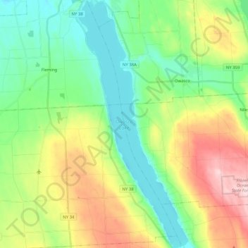
Name: Owasco Lake topographic map, elevation, terrain.
Average elevation: 1,001 ft
Minimum elevation: 682 ft
Maximum elevation: 1,614 ft
Cayuga County trails, hiking, mountain biking, running and outdoor activities
Make a donation
Gear up for your next adventure:
As an Amazon Associate, this site earns from qualifying purchases at no extra cost to you.
Other topographic maps
Click on a map to view its topography, its elevation and its terrain.
Globe Hotel Corners
United States > New York > Cayuga County > Town of Niles
Average elevation: 1,407 ft
Make a donation
Gear up for your next adventure:
As an Amazon Associate, this site earns from qualifying purchases at no extra cost to you.