Geolocate

Santo topographic map

Click on the map to display elevation.

About this map

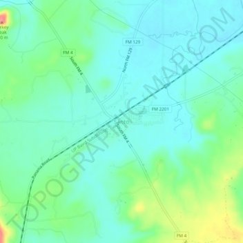
Name: Santo topographic map, elevation, terrain.

Location: Santo, Palo Pinto County, Texas, United States (32.58373 -98.23411 32.62373 -98.19411)

Average elevation: 866 ft

Minimum elevation: 794 ft

Maximum elevation: 1,076 ft

Palo Pinto County trails, hiking, mountain biking, running and outdoor activities

Other topographic maps

Click on a map to view its topography, its elevation and its terrain.

Mineral Wells

United States > Texas > Palo Pinto County

Average elevation: 965 ft

Possum Kingdom Lake

United States > Texas > Palo Pinto County

Average elevation: 1,096 ft

Graford

United States > Texas > Palo Pinto County

Average elevation: 971 ft

Strawn

United States > Texas > Palo Pinto County

Average elevation: 1,024 ft

Gordon

United States > Texas > Palo Pinto County

Average elevation: 1,007 ft

Possum Kingdom Lake

United States > Texas > Palo Pinto County

Average elevation: 1,096 ft

Gear up for your next adventure:

❄️Traction Cleats - Prevent slips on icy trails during winter hikes
🧺Microfiber Travel Towels - Compact and fast-drying towels for trail use
🔥Fast-Boil Camping Stoves - Efficient cooking systems for quick trail meals
🧭Hiking Compass - Precision compass for reliable navigation in the wilderness
Backpacking Tents - Weight-optimized shelters for multi-day topographic surveys

As an Amazon Associate, this site earns from qualifying purchases at no extra cost to you.