
Make a donation
Gear up for your next adventure:
As an Amazon Associate, this site earns from qualifying purchases at no extra cost to you.
Weiten topographic map
Click on the map to display elevation.
Make a donation
Gear up for your next adventure:
As an Amazon Associate, this site earns from qualifying purchases at no extra cost to you.
Weiten
1984 beging das Dorf eine Woche lang die 1350-Jahr-Feier. Aus diesem Fest entstand das alljährliche Kaapesfescht, der Höhepunkt des Weitener Dorfgeschehens bis ins Jahr 2014. Das 30. Jubiläum des Dorffestes war die bislang letzte Auflage des Kaapesfescht. Gründe hierfür sind stark rückläufige Besucherzahlen und klamme Vereinskassen der vielen Weitener Vereine, welche das Dorffest bis dahin ausrichteten.
Make a donation
Gear up for your next adventure:
As an Amazon Associate, this site earns from qualifying purchases at no extra cost to you.
About this map
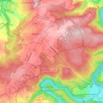
Name: Weiten topographic map, elevation, terrain.
Average elevation: 1,129 ft
Minimum elevation: 482 ft
Maximum elevation: 1,490 ft
Make a donation
Gear up for your next adventure:
As an Amazon Associate, this site earns from qualifying purchases at no extra cost to you.
Other topographic maps
Click on a map to view its topography, its elevation and its terrain.