
Make a donation
Gear up for your next adventure:
As an Amazon Associate, this site earns from qualifying purchases at no extra cost to you.
Riner topographic map
Click on the map to display elevation.
Make a donation
Gear up for your next adventure:
As an Amazon Associate, this site earns from qualifying purchases at no extra cost to you.
About this map
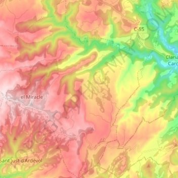
Name: Riner topographic map, elevation, terrain.
Location: Riner, Solsonés, Lérida, Cataluña, España (41.87331 1.49940 41.96440 1.61188)
Average elevation: 2,264 ft
Minimum elevation: 1,490 ft
Maximum elevation: 2,844 ft
Make a donation
Gear up for your next adventure:
As an Amazon Associate, this site earns from qualifying purchases at no extra cost to you.
Other topographic maps
Click on a map to view its topography, its elevation and its terrain.
Make a donation
Gear up for your next adventure:
As an Amazon Associate, this site earns from qualifying purchases at no extra cost to you.
Font dels Enamorats
España > Cataluña > Solsonés > Sant Llorenç de Morunys
Average elevation: 3,353 ft
Torrent de la Foranca
España > Cataluña > Solsonés > Guixers > la Casa Nova de Valls
Average elevation: 3,415 ft
Ardèvol
España > Cataluña > Solsonés > Pinós
Ardévol (en catalán y como nombre oficial Ardèvol) es una localidad y pedanía española perteneciente al municipio de Pinós, situado al sur de la comarca del Solsonés, en la provincia de Lérida, comunidad autónoma de Cataluña. Se encuentra a una altitud de 728 m sobre el nivel del mar, a pie de la…
Average elevation: 2,411 ft
Make a donation
Gear up for your next adventure:
As an Amazon Associate, this site earns from qualifying purchases at no extra cost to you.