Long Beach topographic map
Interactive map
Click on the map to display elevation.
About this map
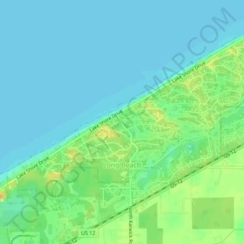
Name: Long Beach topographic map, elevation, terrain.
Location: Long Beach, LaPorte County, Indiana, United States (41.73343 -86.87546 41.75464 -86.83638)
Average elevation: 604 ft
Minimum elevation: 574 ft
Maximum elevation: 673 ft
Other topographic maps
Click on a map to view its topography, its elevation and its terrain.
Michigan City
United States > Indiana > LaPorte County
Michigan City, LaPorte County, Indiana, United States
Average elevation: 617 ft
Fish Lake
United States > Indiana > LaPorte County
Fish Lake, LaPorte County, Indiana, 46365, United States
Average elevation: 705 ft
Trail Creek
United States > Indiana > LaPorte County
Trail Creek, LaPorte County, Indiana, United States
Average elevation: 636 ft
Kingsbury
United States > Indiana > LaPorte County
Kingsbury, LaPorte County, Indiana, 46345, United States
Average elevation: 745 ft
Fish Creek
United States > Indiana > LaPorte County
Fish Creek, LaPorte County, Indiana, 46365, United States
Average elevation: 712 ft
La Porte
United States > Indiana > LaPorte County
La Porte, LaPorte County, Indiana, 46350, United States
Average elevation: 810 ft