
Make a donation
Gear up for your next adventure:
As an Amazon Associate, this site earns from qualifying purchases at no extra cost to you.
DuBois topographic map
Click on the map to display elevation.
Make a donation
Gear up for your next adventure:
As an Amazon Associate, this site earns from qualifying purchases at no extra cost to you.
About this map
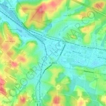
Name: DuBois topographic map, elevation, terrain.
Average elevation: 1,617 ft
Minimum elevation: 1,362 ft
Maximum elevation: 2,247 ft
Clearfield County trails, hiking, mountain biking, running and outdoor activities
Make a donation
Gear up for your next adventure:
As an Amazon Associate, this site earns from qualifying purchases at no extra cost to you.
Other topographic maps
Click on a map to view its topography, its elevation and its terrain.
Kylertown
United States > Pennsylvania > Clearfield County > Cooper Township
Average elevation: 1,591 ft
Penfield
United States > Pennsylvania > Clearfield County > Huston Township
Average elevation: 1,437 ft
Bloomington
United States > Pennsylvania > Clearfield County > Pike Township
Average elevation: 1,417 ft
Make a donation
Gear up for your next adventure:
As an Amazon Associate, this site earns from qualifying purchases at no extra cost to you.
Morrisdale
United States > Pennsylvania > Clearfield County > Morris Township
Average elevation: 1,594 ft
Make a donation
Gear up for your next adventure:
As an Amazon Associate, this site earns from qualifying purchases at no extra cost to you.
Pottersdale
United States > Pennsylvania > Clearfield County > Karthaus Township
Average elevation: 1,293 ft
Drifting
United States > Pennsylvania > Clearfield County > Cooper Township
Average elevation: 1,526 ft
Make a donation
Gear up for your next adventure:
As an Amazon Associate, this site earns from qualifying purchases at no extra cost to you.
Drifting
United States > Pennsylvania > Clearfield County > Cooper Township
Average elevation: 1,526 ft
Frenchville
United States > Pennsylvania > Clearfield County > Covington Township
Average elevation: 1,437 ft
Mount Hope
United States > Pennsylvania > Clearfield County > Lawrence Township
Average elevation: 1,375 ft
Make a donation
Gear up for your next adventure:
As an Amazon Associate, this site earns from qualifying purchases at no extra cost to you.
Sylvis
United States > Pennsylvania > Clearfield County > Burnside Township
Average elevation: 1,650 ft
Utahville
United States > Pennsylvania > Clearfield County > Beccaria Township > Utahville
Average elevation: 1,650 ft