
Make a donation
Gear up for your next adventure:
As an Amazon Associate, this site earns from qualifying purchases at no extra cost to you.
Marchena Island topographic map
Click on the map to display elevation.
Make a donation
Gear up for your next adventure:
As an Amazon Associate, this site earns from qualifying purchases at no extra cost to you.
Marchena Island
The island's name, Marchena Island (Spanish: Isla Marchena), comes from the Spanish monk, Frey Antonio de Marchena. It has an area of 130 km2 and a maximum altitude of 343 meters. The island is not set up for visitors, although the surrounding water is used by aquatic divers on organised tours.
Make a donation
Gear up for your next adventure:
As an Amazon Associate, this site earns from qualifying purchases at no extra cost to you.
About this map
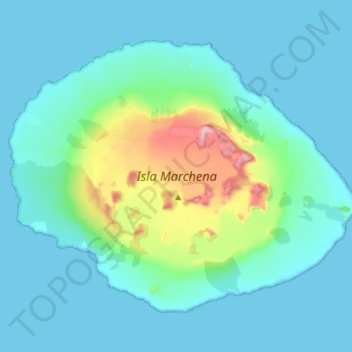
Name: Marchena Island topographic map, elevation, terrain.
Location: Marchena Island, Cantón Santa Cruz, Galápagos, Ecuador (0.27666 -90.54303 0.38680 -90.40060)
Average elevation: 164 ft
Minimum elevation: -3 ft
Maximum elevation: 1,099 ft
Make a donation
Gear up for your next adventure:
As an Amazon Associate, this site earns from qualifying purchases at no extra cost to you.
Other topographic maps
Click on a map to view its topography, its elevation and its terrain.