Geolocate

Bribri topographic map

Click on the map to display elevation.

About this map

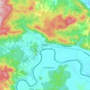
Name: Bribri topographic map, elevation, terrain.

Location: Bribri, Bratsi, Cantón de Talamanca, 70401, Costa Rica (9.58556 -82.89281 9.66556 -82.81281)

Average elevation: 443 ft

Minimum elevation: 10 ft

Maximum elevation: 1,453 ft

Gear up for your next adventure:

🔋Rechargeable Batteries - Power up your outdoor devices
🌡️Portable Weather Meter - Track weather conditions on the trail
🎒Hydration Pack - Hands‑free water reservoir for long hikes
🧷Carabiner Set - Durable clips for gear attachment
🕶️GPS Smartphone Mount - Secure mount for phone navigation

As an Amazon Associate, this site earns from qualifying purchases at no extra cost to you.