
Make a donation
Gear up for your next adventure:
As an Amazon Associate, this site earns from qualifying purchases at no extra cost to you.
Loskop Dam topographic map
Click on the map to display elevation.
Make a donation
Gear up for your next adventure:
As an Amazon Associate, this site earns from qualifying purchases at no extra cost to you.
About this map
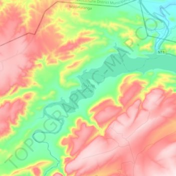
Name: Loskop Dam topographic map, elevation, terrain.
Average elevation: 3,973 ft
Minimum elevation: 3,091 ft
Maximum elevation: 4,974 ft
Make a donation
Gear up for your next adventure:
As an Amazon Associate, this site earns from qualifying purchases at no extra cost to you.
Other topographic maps
Click on a map to view its topography, its elevation and its terrain.
Middelburg
South Africa > Mpumalanga > Nkangala > Steve Tshwete Local Municipality
Average elevation: 4,898 ft
Hendrina
South Africa > Mpumalanga > Nkangala > Steve Tshwete Local Municipality
Average elevation: 5,486 ft
Steve Tshwete Ward 11
South Africa > Mpumalanga > Nkangala > Steve Tshwete Local Municipality
Average elevation: 4,987 ft
Middelburg
South Africa > Mpumalanga > Nkangala > Steve Tshwete Local Municipality
Average elevation: 4,898 ft
Make a donation
Gear up for your next adventure:
As an Amazon Associate, this site earns from qualifying purchases at no extra cost to you.
Middelburg
South Africa > Mpumalanga > Nkangala > Steve Tshwete Local Municipality
Average elevation: 4,898 ft
Middelburg
South Africa > Mpumalanga > Nkangala > Steve Tshwete Local Municipality
Average elevation: 4,898 ft
Steve Tshwete Ward 11
South Africa > Mpumalanga > Nkangala > Steve Tshwete Local Municipality
Average elevation: 4,987 ft