Geolocate

Hisarya topographic map

Click on the map to display elevation.

About this map

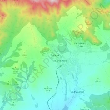
Name: Hisarya topographic map, elevation, terrain.

Location: Hisarya, Hisaria, Plovdiv, 4180, Bulgaria (42.47328 24.65485 42.55328 24.73485)

Average elevation: 1,493 ft

Minimum elevation: 981 ft

Maximum elevation: 2,910 ft

Other topographic maps

Click on a map to view its topography, its elevation and its terrain.

Западен

Bulgaria > Plovdiv > Plovdiv

Average elevation: 564 ft

Hisaria

Bulgaria > Plovdiv

Average elevation: 1,719 ft

Южен

Bulgaria > Plovdiv

Average elevation: 568 ft

Източен

Bulgaria > Plovdiv

Average elevation: 522 ft

Южен

Bulgaria > Plovdiv

Average elevation: 568 ft

Централен

Bulgaria > Plovdiv

Average elevation: 551 ft

Gear up for your next adventure:

📦Gear Storage Bags - Organize and protect outdoor equipment
🥄Camping Utensil Set - Lightweight utensils for outdoor meals
🥾Hiking Shoes - Durable and comfortable shoes for trail hiking
🕶️GPS Smartphone Mount - Secure mount for phone navigation
🦺Reflective Outdoor Gear - Safety gear for low‑light conditions

As an Amazon Associate, this site earns from qualifying purchases at no extra cost to you.