
Make a donation
Gear up for your next adventure:
As an Amazon Associate, this site earns from qualifying purchases at no extra cost to you.
North topographic map
Click on the map to display elevation.
Make a donation
Gear up for your next adventure:
As an Amazon Associate, this site earns from qualifying purchases at no extra cost to you.
North
Rainfall is very irregular as topography and distance from the sea strongly influence precipitation levels, even at short distances. The inland mountainous areas in the northwest around the peaks of Peneda, Gerês and Marão have the highest rainfall in all of Portugal. The Douro valley, however, is among the driest areas in all of Portugal. Some rainy cities include Vila Real, Braga and, on the coast, Viana do Castelo. The coast tends to have balmy weather, high solar irradiance and lower rainfall in a strip from Cape Santo André to the urban area of Porto.
Make a donation
Gear up for your next adventure:
As an Amazon Associate, this site earns from qualifying purchases at no extra cost to you.
About this map
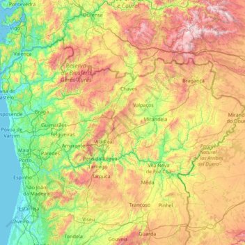
Name: North topographic map, elevation, terrain.
Location: North, Portugal (40.75876 -8.88096 42.15431 -6.18916)
Average elevation: 1,936 ft
Minimum elevation: -7 ft
Maximum elevation: 7,028 ft
Make a donation
Gear up for your next adventure:
As an Amazon Associate, this site earns from qualifying purchases at no extra cost to you.
Other topographic maps
Click on a map to view its topography, its elevation and its terrain.
Make a donation
Gear up for your next adventure:
As an Amazon Associate, this site earns from qualifying purchases at no extra cost to you.
Adingeiro
Portugal > Castelo Branco > Monsanto e Idanha-a-Velha > Monsanto
Average elevation: 1,457 ft