Geolocate

Sahara topographic map

Click on the map to display elevation.

About this map

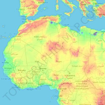
Name: Sahara topographic map, elevation, terrain.

Location: Sahara, Algeria (12.18973 -17.10463 30.35095 33.34349)

Average elevation: 1,066 ft

Minimum elevation: -256 ft

Maximum elevation: 12,359 ft

Gear up for your next adventure:

🛠️Backpacking Tool Kit - Essential toolkit for outdoor repairs
🦶Carbon Trekking Poles - Reduce knee impact on steep descents with ultra-light poles
🔭Compact Binoculars - HD vision for scouting terrain and identifying distant landmarks
🚑Emergency Bivvies - Heat-reflective sleeping bags for survival situations
GPS Sports Watch - GPS watch for running, hiking and training

As an Amazon Associate, this site earns from qualifying purchases at no extra cost to you.