
Thank you for supporting this site ❤️
Make a donation
Make a donation
Gear up for your next adventure:
As an Amazon Associate, this site earns from qualifying purchases at no extra cost to you.
Cehegín topographic map
Click on the map to display elevation.
Thank you for supporting this site ❤️
Make a donation
Make a donation
Gear up for your next adventure:
As an Amazon Associate, this site earns from qualifying purchases at no extra cost to you.
About this map
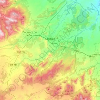
Name: Cehegín topographic map, elevation, terrain.
Location: Cehegín, Noroeste, Region of Murcia, 30430, Spain (37.94497 -1.83329 38.18584 -1.62568)
Average elevation: 2,375 ft
Minimum elevation: 1,053 ft
Maximum elevation: 4,626 ft
Thank you for supporting this site ❤️
Make a donation
Make a donation
Gear up for your next adventure:
As an Amazon Associate, this site earns from qualifying purchases at no extra cost to you.