Geolocate

Nespelem topographic map

Click on the map to display elevation.

About this map

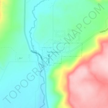
Name: Nespelem topographic map, elevation, terrain.

Location: Nespelem, Okanogan County, Washington, United States (48.16380 -118.97928 48.16938 -118.96414)

Average elevation: 2,018 ft

Minimum elevation: 1,755 ft

Maximum elevation: 2,539 ft

Okanogan County trails, hiking, mountain biking, running and outdoor activities

Other topographic maps

Click on a map to view its topography, its elevation and its terrain.

Wauconda

United States > Washington > Okanogan County

Average elevation: 3,881 ft

Havillah

United States > Washington > Okanogan County

Average elevation: 3,665 ft

Mount Barney

United States > Washington > Okanogan County

Average elevation: 6,683 ft

Aeneas Mountain

United States > Washington > Okanogan County

Average elevation: 4,117 ft

Point Defiance

United States > Washington > Okanogan County

Average elevation: 6,033 ft

Baker Mountain

United States > Washington > Okanogan County

Average elevation: 2,959 ft

Mission Peak

United States > Washington > Okanogan County

Average elevation: 4,816 ft

Rock Mountain

United States > Washington > Okanogan County

Average elevation: 7,067 ft

Gear up for your next adventure:

🕶️GPS Smartphone Mount - Secure mount for phone navigation
📶Satellite Messenger - Communication device off‑grid
🔋Solar Power Banks - Keep your GPS and phone charged in remote wilderness areas
🧣Merino Neck Gaiters - Multi-functional headwear for wind and sun protection
📦Gear Storage Bags - Organize and protect outdoor equipment

As an Amazon Associate, this site earns from qualifying purchases at no extra cost to you.