
Make a donation
Gear up for your next adventure:
As an Amazon Associate, this site earns from qualifying purchases at no extra cost to you.
Cedarville topographic map
Click on the map to display elevation.
Make a donation
Gear up for your next adventure:
As an Amazon Associate, this site earns from qualifying purchases at no extra cost to you.
About this map
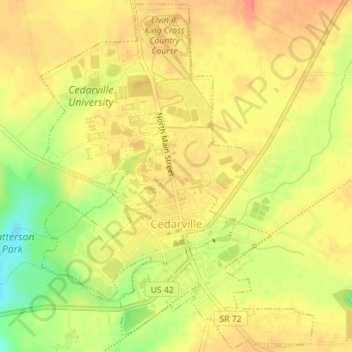
Name: Cedarville topographic map, elevation, terrain.
Average elevation: 1,043 ft
Minimum elevation: 948 ft
Maximum elevation: 1,089 ft
Greene County trails, hiking, mountain biking, running and outdoor activities
Make a donation
Gear up for your next adventure:
As an Amazon Associate, this site earns from qualifying purchases at no extra cost to you.
Other topographic maps
Click on a map to view its topography, its elevation and its terrain.
John Bryan State Park
United States > Ohio > Greene County > Yellow Springs > Clifton
Average elevation: 1,014 ft
Make a donation
Gear up for your next adventure:
As an Amazon Associate, this site earns from qualifying purchases at no extra cost to you.
New Germany
United States > Ohio > Greene County > Beavercreek > New Germany
Average elevation: 922 ft