Geolocate

Rodney topographic map

Click on the map to display elevation.

About this map

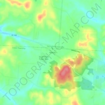
Name: Rodney topographic map, elevation, terrain.

Location: Rodney, Green Township, Gallia County, Ohio, United States (38.82925 -82.32404 38.86925 -82.28404)

Average elevation: 705 ft

Minimum elevation: 600 ft

Maximum elevation: 876 ft

Gallia County trails, hiking, mountain biking, running and outdoor activities

Other topographic maps

Click on a map to view its topography, its elevation and its terrain.

Springfield Township

United States > Ohio > Gallia County

Average elevation: 705 ft

Centerville

United States > Ohio > Gallia County

Average elevation: 725 ft

Cheshire

United States > Ohio > Gallia County

Average elevation: 591 ft

Vinton

United States > Ohio > Gallia County

Average elevation: 679 ft

Crown City

United States > Ohio > Gallia County

Average elevation: 663 ft

Gear up for your next adventure:

🧢Sun Protection Hats - Wide-brimmed and UPF-rated hats for high-altitude sun safety
📻Weather Alert Radios - Stay informed of storm risks while off-the-grid
🧦Merino Wool Socks - Moisture-wicking, blister-preventing socks for long treks
🧺Microfiber Travel Towels - Compact and fast-drying towels for trail use
📌Outdoor GPS Map App - Apps and devices for digital topographic navigation

As an Amazon Associate, this site earns from qualifying purchases at no extra cost to you.