
Make a donation
Gear up for your next adventure:
As an Amazon Associate, this site earns from qualifying purchases at no extra cost to you.
Talagante topographic map
Click on the map to display elevation.
Make a donation
Gear up for your next adventure:
As an Amazon Associate, this site earns from qualifying purchases at no extra cost to you.
About this map
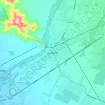
Name: Talagante topographic map, elevation, terrain.
Average elevation: 1,178 ft
Minimum elevation: 948 ft
Maximum elevation: 2,782 ft
Make a donation
Gear up for your next adventure:
As an Amazon Associate, this site earns from qualifying purchases at no extra cost to you.
Other topographic maps
Click on a map to view its topography, its elevation and its terrain.
Talagante
Chile > Región Metropolitana de Santiago > Provincia de Talagante
Average elevation: 1,348 ft
Isla de Maipo
Chile > Región Metropolitana de Santiago > Provincia de Talagante
Average elevation: 1,473 ft
Humedal Urbano Río Maipo de Isla de Maipo
Chile > Región Metropolitana de Santiago > Provincia de Talagante > El Monte
Average elevation: 1,365 ft
Padre Hurtado
Chile > Región Metropolitana de Santiago > Provincia de Talagante
Average elevation: 1,552 ft
Make a donation
Gear up for your next adventure:
As an Amazon Associate, this site earns from qualifying purchases at no extra cost to you.
El Monte
Chile > Región Metropolitana de Santiago > Provincia de Talagante
Average elevation: 1,175 ft
Peñaflor
Chile > Región Metropolitana de Santiago > Provincia de Talagante
Average elevation: 1,394 ft
Talagante
Chile > Región Metropolitana de Santiago > Provincia de Talagante
Average elevation: 1,348 ft
Isla de Maipo
Chile > Región Metropolitana de Santiago > Provincia de Talagante
Average elevation: 1,473 ft
Make a donation
Gear up for your next adventure:
As an Amazon Associate, this site earns from qualifying purchases at no extra cost to you.
Talagante
Chile > Región Metropolitana de Santiago > Provincia de Talagante
Average elevation: 1,348 ft
Isla de Maipo
Chile > Región Metropolitana de Santiago > Provincia de Talagante
Average elevation: 1,473 ft
Peñaflor
Chile > Región Metropolitana de Santiago > Provincia de Talagante
Average elevation: 1,394 ft
Peñaflor
Chile > Región Metropolitana de Santiago > Provincia de Talagante
Average elevation: 1,394 ft
Make a donation
Gear up for your next adventure:
As an Amazon Associate, this site earns from qualifying purchases at no extra cost to you.
Peñaflor
Chile > Región Metropolitana de Santiago > Provincia de Talagante
Average elevation: 1,394 ft