
Make a donation
Gear up for your next adventure:
As an Amazon Associate, this site earns from qualifying purchases at no extra cost to you.
Budd Lake topographic map
Click on the map to display elevation.
Make a donation
Gear up for your next adventure:
As an Amazon Associate, this site earns from qualifying purchases at no extra cost to you.
Budd Lake
Budd Lake, which the community is named after, is the source of the South Branch Raritan River. A glacial lake at an elevation of 933 feet (284 m), Budd Lake has a surface area of 374 acres (1.51 km2). It is 7–12 feet deep, and can have large algal blooms. The bog, created by thousands of years of decaying plant material, supports wetland plants such as black spruce and tamarack, which grow on the floating mass. The lake is recharged through groundwater seepage through a series of wetlands, and serves as the headwaters of the Raritan River's South Branch. It is closely bordered by U.S. Route 46 to the south, and Sand Shore Road to the east.
Make a donation
Gear up for your next adventure:
As an Amazon Associate, this site earns from qualifying purchases at no extra cost to you.
About this map
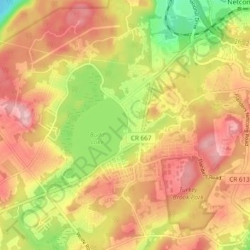
Name: Budd Lake topographic map, elevation, terrain.
Average elevation: 1,027 ft
Minimum elevation: 732 ft
Maximum elevation: 1,240 ft
Morris County trails, hiking, mountain biking, running and outdoor activities
Make a donation
Gear up for your next adventure:
As an Amazon Associate, this site earns from qualifying purchases at no extra cost to you.