Geolocate

Frenchboro topographic map

Click on the map to display elevation.

About this map

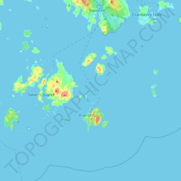
Name: Frenchboro topographic map, elevation, terrain.

Location: Frenchboro, Hancock County, Maine, 04635, United States (44.05059 -68.49465 44.24946 -68.16839)

Average elevation: 7 ft

Minimum elevation: -10 ft

Maximum elevation: 213 ft

Hancock County trails, hiking, mountain biking, running and outdoor activities

Other topographic maps

Click on a map to view its topography, its elevation and its terrain.

Catamount

United States > Maine > Hancock County > Sullivan

Average elevation: 213 ft

Flat Island

United States > Maine > Hancock County > Deer Isle

Average elevation: 26 ft

Sunset

United States > Maine > Hancock County > Deer Isle

Average elevation: 46 ft

Somesville

United States > Maine > Hancock County > Mount Desert

Average elevation: 72 ft

Sargentville

United States > Maine > Hancock County > Sedgwick

Average elevation: 98 ft

Minturn

United States > Maine > Hancock County > Swan's Island

Average elevation: 46 ft

Harborside

United States > Maine > Hancock County > Brooksville

Average elevation: 43 ft

East Orland

United States > Maine > Hancock County > Orland

Average elevation: 194 ft

East Blue Hill

United States > Maine > Hancock County > Blue Hill

Average elevation: 98 ft

Atlantic

United States > Maine > Hancock County > Swan's Island

Average elevation: 36 ft

Duck Mountain

United States > Maine > Hancock County

Average elevation: 781 ft

Birch Harbor

United States > Maine > Hancock County > Gouldsboro

Average elevation: 82 ft

Little Deer Isle

United States > Maine > Hancock County > Deer Isle

Average elevation: 102 ft

Salsbury Cove

United States > Maine > Hancock County > Bar Harbor

Average elevation: 49 ft

Somes Sound

United States > Maine > Hancock County > Mount Desert

Average elevation: 187 ft

Sunshine

United States > Maine > Hancock County > Deer Isle

Average elevation: 10 ft

Gear up for your next adventure:

📷Action Camera - Capture your outdoor adventures in HD
📡Handheld GPS Device - Reliable handheld GPS for outdoor navigation
🥘Titanium Cookware - Durable, featherlight pots and pans for backpacking
🏫Relief Map Kits - Hands-on tools for teaching landforms and elevation
🔋Rechargeable Batteries - Power up your outdoor devices

As an Amazon Associate, this site earns from qualifying purchases at no extra cost to you.