
Surnadal topographic map
Interactive map
Click on the map to display elevation.
About this map
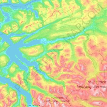
Name: Surnadal topographic map, elevation, terrain.
Location: Surnadal, Møre og Romsdal, Norway (62.71177 8.24371 63.13392 9.36483)
Average elevation: 1,713 ft
Minimum elevation: -3 ft
Maximum elevation: 5,932 ft
Other topographic maps
Click on a map to view its topography, its elevation and its terrain.
Vinje
Norway > Møre og Romsdal > Geiranger
Vinje, Geiranger, Stranda, Møre og Romsdal, 6216, Norway
Average elevation: 1,844 ft
Bloomberg
Bloomberg, Stranda, Møre og Romsdal, Norway
Average elevation: 1,073 ft
Raudnesvika naturreservat
Raudnesvika naturreservat, Sula, Møre og Romsdal, Norway
Average elevation: 610 ft
Grodås
Grodås, Volda, Møre og Romsdal, 6763, Norway
Average elevation: 1,001 ft
Omsa
Omsa, Kristiansund, Møre og Romsdal, 6522, Norway
Average elevation: 92 ft
Grøa
Norway > Møre og Romsdal > Grøa
Grøa, Sunndal, Møre og Romsdal, 6612, Norway
Average elevation: 1,673 ft
Norddal
Norddal, Fjord, Møre og Romsdal, 6214, Norway
Average elevation: 1,194 ft
Geiranger
Geiranger, Stranda, Møre og Romsdal, 6216, Norway
Average elevation: 1,834 ft