Geolocate

Ter topographic map

Interactive map

Click on the map to display elevation.

About this map

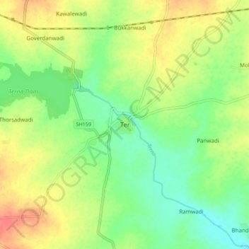
Name: Ter topographic map, elevation, terrain.

Location: Ter, Dharashiv, Maharashtra, 413508, India (18.27984 76.10115 18.35984 76.18115)

Average elevation: 2,136 ft

Minimum elevation: 2,057 ft

Maximum elevation: 2,234 ft

Other topographic maps

Click on a map to view its topography, its elevation and its terrain.

Gairan Wasti

India > Maharashtra > Dharashiv > Waruda

Gairan Wasti, Waruda, Dharashiv, Maharashtra, India

Average elevation: 2,175 ft

Yedshi

India > Maharashtra > Dharashiv

Yedshi, Dharashiv, Maharashtra, 413405, India

Average elevation: 2,244 ft