Geolocate

Malibayo topographic map

Click on the map to display elevation.

About this map
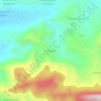
Name: Malibayo topographic map, elevation, terrain.

Location: Malibayo, Batangas City, Batangas, Calabarzon, 4200, Philippines (13.65204 121.06305 13.69204 121.10305)

Average elevation: 886 ft

Minimum elevation: 43 ft

Maximum elevation: 2,562 ft

Other topographic maps

Click on a map to view its topography, its elevation and its terrain.
Santa Clara

Philippines > Batangas > Batangas City

Average elevation: 16 ft

Verde Island

Philippines > Batangas > Batangas City

Average elevation: 171 ft

Kumintang Ilaya

Philippines > Batangas > Batangas City

Average elevation: 121 ft

Balete

Philippines > Batangas > Batangas City

Average elevation: 476 ft

Malalim

Philippines > Batangas > Batangas City

Average elevation: 174 ft

Bucal

Philippines > Batangas > Batangas City

Average elevation: 476 ft

Concepcion

Philippines > Batangas > Batangas City

Average elevation: 486 ft

Pallocan West

Philippines > Batangas > Batangas City

Average elevation: 52 ft

Gear up for your next adventure:

⛑️Personal Locator Beacon - Safety beacon for emergencies
📱Solar Portable Charger - Solar power bank for charging devices off‑grid
🧤Hiking Gloves - Protective gloves for rugged trails
🔥Fast-Boil Camping Stoves - Efficient cooking systems for quick trail meals
📚Navigation Handbooks - Master the art of reading topographic maps and using a compass

As an Amazon Associate, this site earns from qualifying purchases at no extra cost to you.