
Hiddenhausen topographic map
Interactive map
Click on the map to display elevation.
About this map
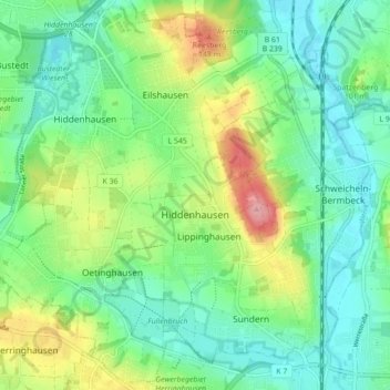
Name: Hiddenhausen topographic map, elevation, terrain.
Average elevation: 302 ft
Minimum elevation: 180 ft
Maximum elevation: 568 ft
Other topographic maps
Click on a map to view its topography, its elevation and its terrain.
Vlotho
Duitsland > Noordrijn-Westfalen > Kreis Herford
Vlotho, Kreis Herford, Noordrijn-Westfalen, 32602, Duitsland
Average elevation: 489 ft
Kirchlengern
Duitsland > Noordrijn-Westfalen > Kreis Herford
Kirchlengern, Kreis Herford, Noordrijn-Westfalen, Duitsland
Average elevation: 262 ft
Bonneberg
Duitsland > Noordrijn-Westfalen > Kreis Herford > Vlotho > Bonneberg
Bonneberg, Vlotho, Kreis Herford, Noordrijn-Westfalen, 32602, Duitsland
Average elevation: 492 ft
Löhne
Duitsland > Noordrijn-Westfalen > Kreis Herford
Löhne, Kreis Herford, Noordrijn-Westfalen, 32584, Duitsland
Average elevation: 305 ft
Vlotho
Duitsland > Noordrijn-Westfalen > Kreis Herford > Vlotho
Vlotho, Kreis Herford, Noordrijn-Westfalen, 32602, Duitsland
Average elevation: 390 ft
Herford-Stadt
Duitsland > Noordrijn-Westfalen > Kreis Herford
Herford-Stadt, Herford, Kreis Herford, Noordrijn-Westfalen, Duitsland
Average elevation: 299 ft