Geolocate

Río Las Ceibas topographic map

Interactive map

Click on the map to display elevation.

About this map

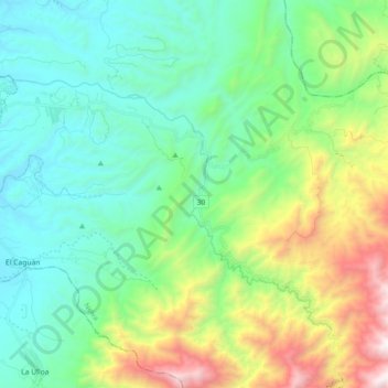
Name: Río Las Ceibas topographic map, elevation, terrain.

Location: Río Las Ceibas, Neiva, Norte, Huila, RAP (Especial) Central, Colombia (2.83226 -75.27071 2.95791 -75.09074)

Average elevation: 3,284 ft

Minimum elevation: 1,552 ft

Maximum elevation: 8,068 ft

Other topographic maps

Click on a map to view its topography, its elevation and its terrain.

Vegalarga

Colombia > Huila > Neiva

Vegalarga, Neiva, Norte, Huila, RAP (Especial) Central, Colombia

Average elevation: 4,472 ft

San Luis

Colombia > Huila > Neiva

San Luis, Neiva, Norte, Huila, RAP (Especial) Central, Colombia

Average elevation: 4,390 ft

AIPECITO

Colombia > Huila > Neiva

AIPECITO, Neiva, Norte, Huila, RAP (Especial) Central, Colombia

Average elevation: 5,653 ft

GUACIRCO

Colombia > Huila > Neiva

GUACIRCO, Neiva, Norte, Huila, RAP (Especial) Central, Colombia

Average elevation: 1,355 ft

Perímetro Urbano Neiva

Colombia > Huila > Neiva

Perímetro Urbano Neiva, Neiva, Norte, Huila, RAP (Especial) Central, Colombia

Average elevation: 1,539 ft

El Caguán

Colombia > Huila > Neiva

El Caguán, Neiva, Norte, Huila, RAP (Especial) Central, Colombia

Average elevation: 1,749 ft