
Make a donation
Gear up for your next adventure:
As an Amazon Associate, this site earns from qualifying purchases at no extra cost to you.
Vegalarga topographic map
Click on the map to display elevation.
Make a donation
Gear up for your next adventure:
As an Amazon Associate, this site earns from qualifying purchases at no extra cost to you.
About this map
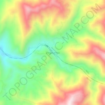
Name: Vegalarga topographic map, elevation, terrain.
Average elevation: 4,472 ft
Minimum elevation: 3,422 ft
Maximum elevation: 5,689 ft
Make a donation
Gear up for your next adventure:
As an Amazon Associate, this site earns from qualifying purchases at no extra cost to you.
Other topographic maps
Click on a map to view its topography, its elevation and its terrain.
Perímetro Urbano Neiva
Debido a su ubicación cerca de la línea del ecuador y su baja altitud, la ciudad tiene se encuentra en el piso térmico cálido con temperaturas anuales promedio durante el día que van desde 21 hasta 35 grado celsius. La variable temperatura siempre guarda cierta relación con la precipitación, de manera…
Average elevation: 1,539 ft