
Thank you for supporting this site ❤️
Make a donation
Make a donation
Gear up for your next adventure:
As an Amazon Associate, this site earns from qualifying purchases at no extra cost to you.
Abiegos topographic map
Click on the map to display elevation.
Thank you for supporting this site ❤️
Make a donation
Make a donation
Gear up for your next adventure:
As an Amazon Associate, this site earns from qualifying purchases at no extra cost to you.
About this map
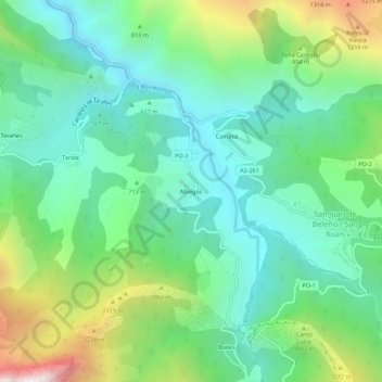
Name: Abiegos topographic map, elevation, terrain.
Location: Abiegos, Ponga, Asturias, 33557, Spain (43.17444 -5.20609 43.21444 -5.16609)
Average elevation: 2,402 ft
Minimum elevation: 1,135 ft
Maximum elevation: 5,525 ft
Thank you for supporting this site ❤️
Make a donation
Make a donation
Gear up for your next adventure:
As an Amazon Associate, this site earns from qualifying purchases at no extra cost to you.