Geolocate

Nelson topographic map

Click on the map to display elevation.

About this map

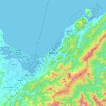
Name: Nelson topographic map, elevation, terrain.

Location: Nelson, 7040, New Zealand (-41.43108 173.12368 -41.11108 173.44368)

Average elevation: 679 ft

Minimum elevation: -3 ft

Maximum elevation: 4,902 ft

Other topographic maps

Click on a map to view its topography, its elevation and its terrain.

Wakapuaka River

New Zealand > Nelson > Nelson

Average elevation: 725 ft

Gear up for your next adventure:

🥇GPS Hiking Watch - Multi‑sport GPS watch with navigation and trail tracking
🦶Hiking Gaiters - Keep debris and water out of your boots
🩹Survival Bandages - High‑quality bandages for emergencies
🔥Plasma Lighters - Windproof lighters that work in any weather condition
🔦Powerful Headlamps - Ultra-bright hands-free lighting for night navigation

As an Amazon Associate, this site earns from qualifying purchases at no extra cost to you.