
Make a donation
Gear up for your next adventure:
As an Amazon Associate, this site earns from qualifying purchases at no extra cost to you.
Tegel topographic map
Click on the map to display elevation.
Make a donation
Gear up for your next adventure:
As an Amazon Associate, this site earns from qualifying purchases at no extra cost to you.
Tegel
Zwischen 1930 und 1934 führte der Verein für Raumschiffahrt auf dem Areal des einstigen Schießplatzes Tegel diverse Versuche mit Flüssigkeitsraketen durch. Trotz zahlreicher Explosionen gelangen Aufstiege in Höhen von bis zu drei Kilometern. Zahlreiche bekannte deutsche Raketenforscher, wie Wernher von Braun, waren Mitglieder des Vereins.
Make a donation
Gear up for your next adventure:
As an Amazon Associate, this site earns from qualifying purchases at no extra cost to you.
About this map
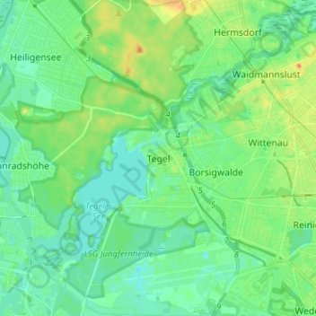
Name: Tegel topographic map, elevation, terrain.
Location: Tegel, Reinickendorf, Berlin, Deutschland (52.54881 13.22098 52.62613 13.32154)
Average elevation: 128 ft
Minimum elevation: 85 ft
Maximum elevation: 223 ft
Make a donation
Gear up for your next adventure:
As an Amazon Associate, this site earns from qualifying purchases at no extra cost to you.
Other topographic maps
Click on a map to view its topography, its elevation and its terrain.
Teufelsberg
Eine Neuvermessung des Instituts für Geodäsie und Geoinformationstechnik der TU Berlin im Jahr 2013 ergab als Höhe 120,1 Meter über NHN, nachdem der Teufelsberg zuvor als 114,7 Meter hoch galt. Das Vermessungsamt Charlottenburg-Wilmersdorf bestätigte dieses Ergebnis. Grund für dieses Höhenwachstum ist,…
Average elevation: 177 ft
Pfaueninsel
Der Kriegsverlauf während der Auseinandersetzungen mit Napoleon ließ aus Sicht Preußens eine enge Verbindung mit Russland ratsam erscheinen. Das Ziel war 1817 erreicht, als die Tochter Friedrich Wilhelms III. den Großfürsten Nikolaus heiratete. 1826 wurde der Schwiegersohn als Nikolaus I. sogar Zar von…
Average elevation: 138 ft
Make a donation
Gear up for your next adventure:
As an Amazon Associate, this site earns from qualifying purchases at no extra cost to you.
Köllnischer Park
Im Jahr 1736 gelangte das Gelände als Schenkung Friedrich Wilhelms I. an General Graf zu Waldburg, der darauf ein Haus bauen und einen ausgedehnten Garten anlegen ließ. Nächster Besitzer war der Kaufmann und Bankier David Splitgerber. Er sorgte für die Erweiterung und Verschönerung des Gartens und betrieb…
Average elevation: 135 ft
Make a donation
Gear up for your next adventure:
As an Amazon Associate, this site earns from qualifying purchases at no extra cost to you.
Großer Müggelberg
Die Müggelberge (früher auch Müggelsberge genannt) sind ein bewaldeter Hügelzug mit Höhen bis zu 114,7 m ü. NHN im Südosten Berlins im Bezirk Treptow-Köpenick. Sie werden durch den Kleinen Müggelberg (88,3 m) und den Großen Müggelberg (114,7 m) dominiert. Die Müggelberge umfassen eine Fläche von…
Average elevation: 144 ft
Make a donation
Gear up for your next adventure:
As an Amazon Associate, this site earns from qualifying purchases at no extra cost to you.
Make a donation
Gear up for your next adventure:
As an Amazon Associate, this site earns from qualifying purchases at no extra cost to you.
Thomashöhe
Die Lessinghöhe und die Thomashöhe sind Erhebungen auf den Neuköllner Rollbergen. Sie entstanden nach dem Zweiten Weltkrieg als Schuttberge und befinden sich im Berliner Ortsteil Neukölln. Die Hügel wurden begrünt und dabei als Naherholungsgebiete gestaltet.
Average elevation: 151 ft
Make a donation
Gear up for your next adventure:
As an Amazon Associate, this site earns from qualifying purchases at no extra cost to you.
Make a donation
Gear up for your next adventure:
As an Amazon Associate, this site earns from qualifying purchases at no extra cost to you.
Botanischer Garten
Bereits bei der Gründung Ende des 19. Jahrhunderts lag nur etwa ein Viertel der Gartenfläche in der „Gemarkung Dahlem“. Der weit größere Teil gehörte zur „Gemarkung Groß-Lichterfelde“ (siehe Höhenplan) und zur Komplettierung der Verwirrung war er postalisch der Landgemeinde Steglitz zugeordnet.
Average elevation: 171 ft
Make a donation
Gear up for your next adventure:
As an Amazon Associate, this site earns from qualifying purchases at no extra cost to you.
Falkenberg
Der Architekt Bruno Taut bekam 1912 von dem damaligen Berliner Spar- und Bauverein (heute: Berliner Bau- und Wohnungsgenossenschaft von 1892 eG) den Auftrag, im Südosten von Berlin im heutigen Bezirk Treptow-Köpenick für ein 75 Hektar großes Gelände unter Berücksichtigung der örtlichen Gegebenheiten als…
Average elevation: 131 ft
Make a donation
Gear up for your next adventure:
As an Amazon Associate, this site earns from qualifying purchases at no extra cost to you.
Görlitzer Park
Der Görlitzer Tunnel (im Berliner Volksmund unter seinem Spitznamen Harnröhre bekannt) war bis mindestens Ende 1989 noch begehbar und wich mit der Öffnung des Parks einer großen Mulde in der Mitte des Parks, die eine Art natürliche Arena bildet. Die ehemaligen Tunnelmauern wurden als Gestaltungselement…
Average elevation: 135 ft
Make a donation
Gear up for your next adventure:
As an Amazon Associate, this site earns from qualifying purchases at no extra cost to you.
Botanischer Garten
Bereits bei der Gründung Ende des 19. Jahrhunderts lag nur etwa ein Viertel der Gartenfläche in der „Gemarkung Dahlem“. Der weit größere Teil gehörte zur „Gemarkung Groß-Lichterfelde“ (siehe Höhenplan) und zur Komplettierung der Verwirrung war er postalisch der Landgemeinde Steglitz zugeordnet.
Average elevation: 171 ft