

Poás topographic map
Click on the map to display elevation.
Poás
Poás has an area of 73.84 km² and a mean elevation of 1,184 metres.
About this map
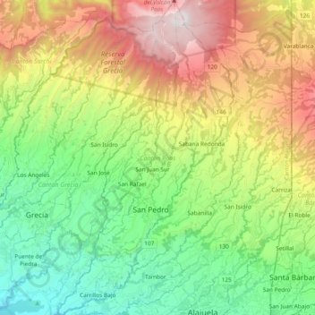
Name: Poás topographic map, elevation, terrain.
Location: Poás, Alajuela Province, Costa Rica (10.01435 -84.29947 10.19766 -84.19558)
Average elevation: 4,692 ft
Minimum elevation: 2,205 ft
Maximum elevation: 8,819 ft
Other topographic maps
Click on a map to view its topography, its elevation and its terrain.





Arenal Volcano
Costa Rica > Alajuela Province > Cantón de San Carlos > La Fortuna
Arenal has several eruptive vents. Chato is a dormant stratovolcanic cone. It is believed that Chato first erupted 38,000 years ago during the Pleistocene period and last erupted about 3,500 years ago. Chatito is a lava dome with an elevation of 1,100 metres (3,609 ft). Espina is another lava dome.
Average elevation: 3,327 ft

Grande River
Costa Rica > Alajuela Province > San Ramón > San Isidro > San Roque
Average elevation: 3,428 ft
La Paz
Costa Rica > Alajuela Province > Cantón de San Ramón > Piedades Norte
Average elevation: 3,825 ft
Río Jesús
Costa Rica > Alajuela Province > San Ramón > San Rafael > Berlín
Average elevation: 4,091 ft

Arenal Volcano
Costa Rica > Alajuela Province > San Carlos > La Fortuna
Arenal has several eruptive vents. Chato is a dormant stratovolcanic cone. It is believed that Chato first erupted 38,000 years ago during the Pleistocene period and last erupted about 3,500 years ago. Chatito is a lava dome with an elevation of 1,100 metres (3,609 ft). Espina is another lava dome.
Average elevation: 3,327 ft

Carrillos Alto
Costa Rica > Alajuela Province > Poás > Carrillos > Carrillos Bajo
Average elevation: 2,989 ft