
Make a donation
Gear up for your next adventure:
As an Amazon Associate, this site earns from qualifying purchases at no extra cost to you.
Schirgiswalde topographic map
Click on the map to display elevation.
Make a donation
Gear up for your next adventure:
As an Amazon Associate, this site earns from qualifying purchases at no extra cost to you.
About this map
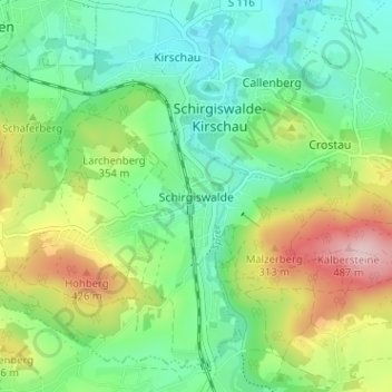
Name: Schirgiswalde topographic map, elevation, terrain.
Average elevation: 1,050 ft
Minimum elevation: 778 ft
Maximum elevation: 1,604 ft
Make a donation
Gear up for your next adventure:
As an Amazon Associate, this site earns from qualifying purchases at no extra cost to you.
Other topographic maps
Click on a map to view its topography, its elevation and its terrain.
Crostau
Deutschland > Sachsen > Bautzen > Schirgiswalde-Kirschau
Crostau ist ein klassisches Gebirgsdorf. Es erstreckt sich auf einer Höhenlage von 245 m bis 380 m. Umrahmt wird es von mehreren Bergen des Oberlausitzer Berglandes: den Kälbersteinen (487 m), dem Potsberg (448 m), dem Wolfsberg (347 m), dem Horken (307 m) und dem Callenberger Berg (360 m). Verschiedene…
Average elevation: 1,020 ft